
When the Fire Came to Squamish: The Dryden Creek Wildfire Story
June 25, 2025
Dr. Mohammadali Hemati, Remote Sensing Specialist.
Squamish, nestled between the steep granite walls of the Stawamus Chief and the shining waters of Howe Sound, is a place where wild nature and everyday life are tightly woven together.
Nearly 28,000 people live here, and many more come to hike its ancient forests, climb its towering cliffs, and explore its world-famous parks and trails. It is a community that thrives on its connection to the land, but that same land can also present serious risks.
On the afternoon of June 9, 2025, that risk became real. Around 4:30 p.m., a wildfire ignited near Dryden Creek, east of Highway 99.
The fire is suspected to be human-caused, raising the question: why did it spread so quickly?
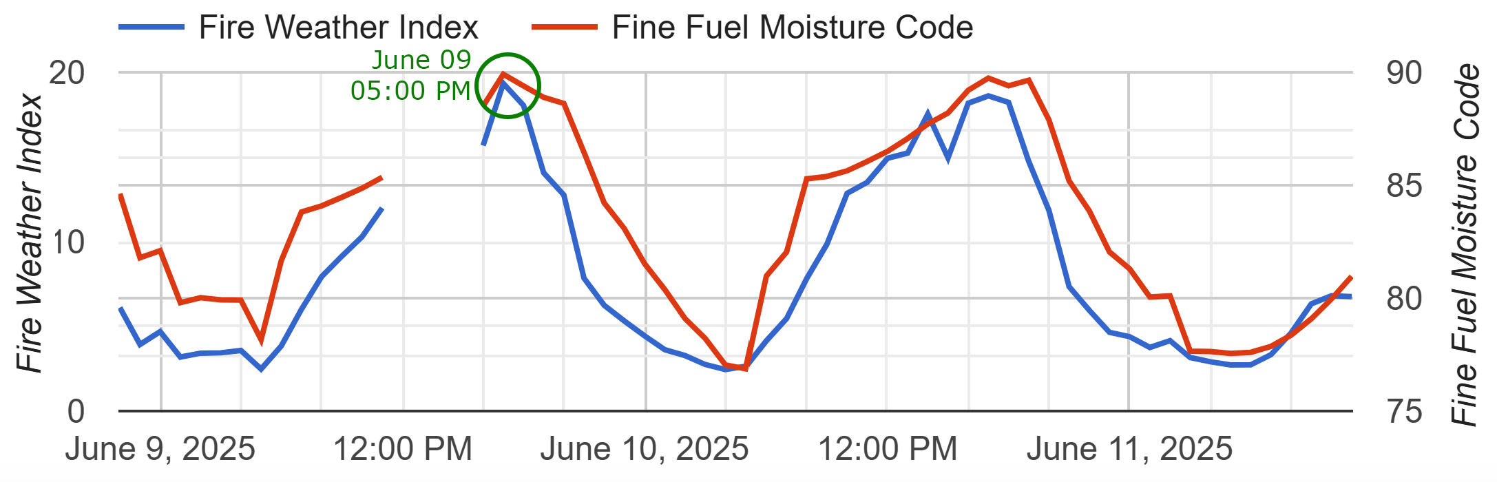
The answer is tied to the conditions on the ground. The area had been sitting in drought, with extremely dry vegetation and forest fuel building up over time. This forest, thick with conifers and dry underbrush, was a high-risk zone waiting for a trigger. Around the same time, data from the Squamish AP weather station (Figure 1) showed that both the Fire Weather Index and the Fine Fuel Moisture Code had peaked just before 5 p.m., a clear sign that the environment was primed to support a fast-moving fire. These indices are not just numbers, they represent how easily vegetation can ignite and how intensely a fire can burn. When these levels are high, even a small spark can quickly turn into an unstoppable flame.
Within hours, the fire’s footprint was growing.
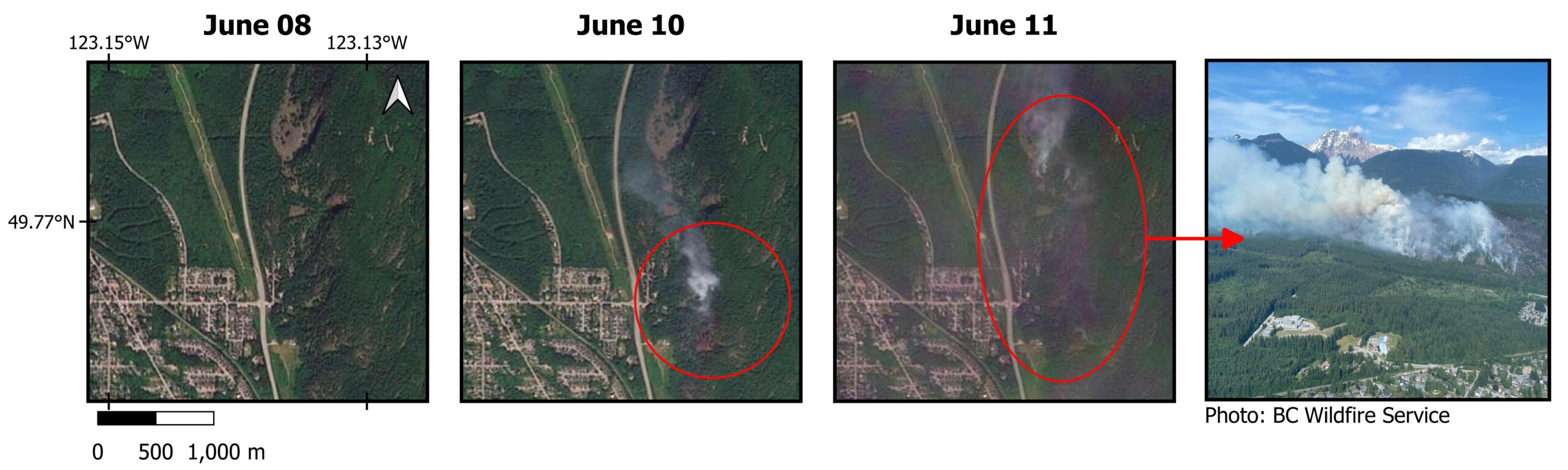
Satellite imagery maps by Sensenet using PlanetScope data (Figure 3) showed the fire’s rapid expansion through the forested hills.
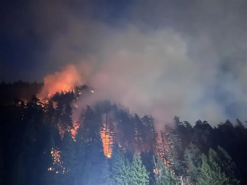
It was not just burning on the ground; it was climbing into the canopy, becoming a crown fire, one of the most difficult and dangerous types to control. Crown fires can leap across treetops, feeding on the dry needles and branches high above, often outpacing ground crews.
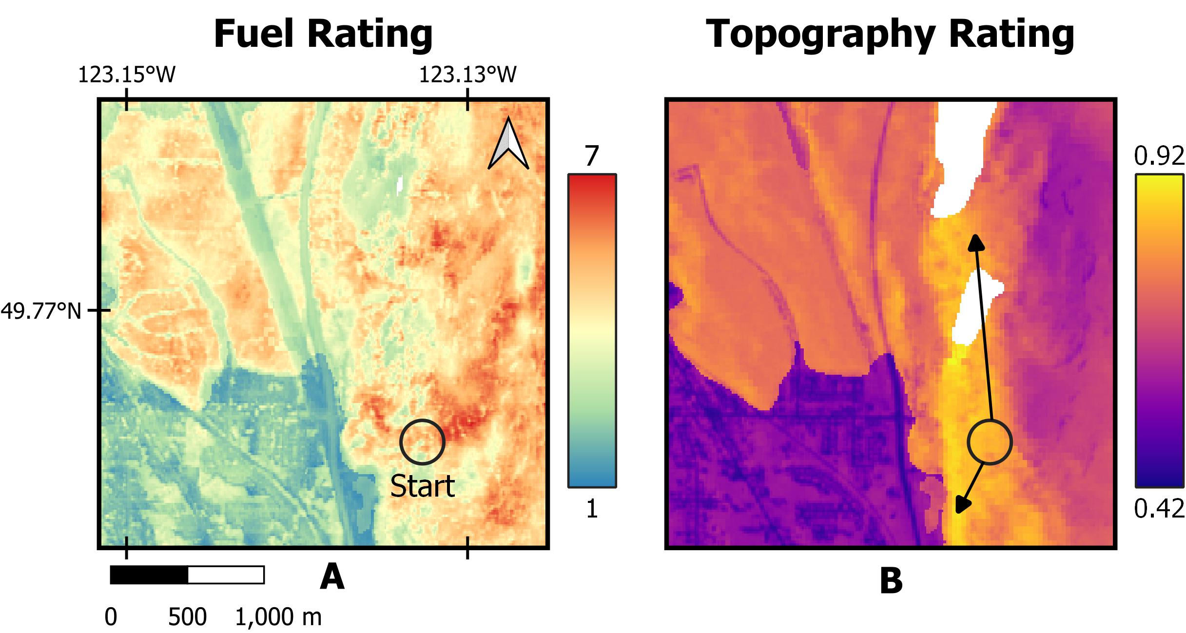
Sensenet’s analysis didn’t stop with mapping the fire’s growth. Our Fuel Index product (Figure 2A) confirmed that the fire had started in an area with heavy combustible material, and our Topography Index (Figure 2B) revealed that the fire was burning on a steep hillside. Fires on slopes are notoriously harder to manage because heat rises and flames naturally climb uphill, moving faster than they would on flat ground.
This topography made it even more challenging for firefighters to control the fire’s advance. The fire grew from about five hectares on the morning of June 10 to over twenty hectares by midday. Afternoon winds drove the flames uphill, pushing the fire north with alarming speed. By the evening of June 11, it surged again, reaching 54 hectares.
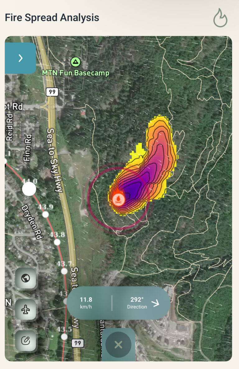
With each shift in the wind, residents and emergency teams anxiously tracked its path, knowing that in these dry conditions, fire could turn suddenly. Sensenet’s fire spread analysis tool (Figure 4), using real-time wind data and remote sensing, predicted that the fire would continue moving north, following both the slope and the wind direction. Our modeling showed the likely paths of fire spread, critical for understanding where the fire might move next.
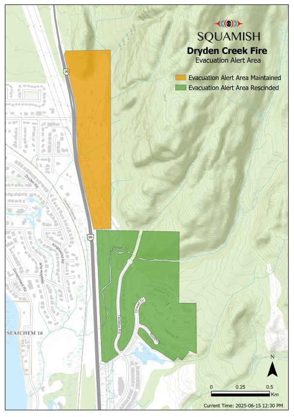
As the fire grew, the Squamish District’s evacuation map (Figure 5) began to highlight the areas most at risk. An Evacuation Alert was issued that evening for homes along Depot Road and nearby campgrounds. For many residents, it became a tense wait. Should they pack up? Should they leave? Some were watching the sky for smoke, while others refreshed emergency updates, hoping for good news.
Within hours of the fire’s ignition, Squamish Fire Rescue and BC Wildfire Service were on the scene. By 7:30 p.m. on June 9, helicopters were already dropping water on the flames. Ground and air crews worked relentlessly in the days that followed, supported by five helicopters, four airtankers, one piece of heavy equipment, and structure protection teams who set up sprinklers and hose lines around homes and infrastructure.
Despite their combined efforts, the steep hillside, dense crown fire, and dry forest fuels created a perfect storm for the fire to grow.
Helicopters flew constant water drops, air tankers made repeated passes, and firefighters worked through punishing terrain where the flames climbed into the treetops. Crown fires made everything harder, leaping from tree to tree, burning high and hot, and sending embers into the air. Falling debris added to the danger, making the firefight not just difficult, but deeply risky.
Alice Lake Provincial Park was closed to protect public safety, and nearby trails were also shut down. As the fire pressed further north, the situation remained unstable.
On June 16, the Squamish District issued an official Evacuation Order for two properties east of Dryden Creek, where hazard trees and the threat of rockfall posed serious risks. The Evacuation Alert stayed in place for several properties along Depot Road even as the fire was declared “held” at around 59.5 hectares. Hotspots and smoldering patches still lingered, and emergency crews worked to strengthen containment lines. Rainfall and cooler weather in the days that followed helped ease the fire’s grip on the landscape.
By June 19, the fire was classified as “under control.” Still, active smoldering remained inside the fire’s perimeter, and the threat from unstable trees and rockfall continued to keep some areas restricted. Throughout this entire event, the Dryden Creek Wildfire became more than just a fight against flames, it became a community story.
Neighbors supported each other, firefighters worked tirelessly, and emergency updates became a daily part of life. The lessons from this fire echo beyond Squamish: even a single spark, under the right conditions, can change everything. This event highlighted the importance of both advanced technology and community resilience.
An Evacuation Alert is still in effect, and residents and visitors should continue monitoring the BC Wildfire Service incident page (Fire Number V30558), the District of Squamish’s Dryden Creek Wildfire updates, and SquamishAlert notifications for the latest information. Sensenet’s remote sensing tools continue to track the situation closely, working to detect any new flare-ups before they can grow. To protect Squamish is to stand for both its people and the wild, untamed beauty that defines its soul.