
The Early Warning: Sensenet's Role in Containing the Whelan Creek Fire
July 8, 2025
Dr. Mohammadali Hemati, Remote Sensing Specialist.
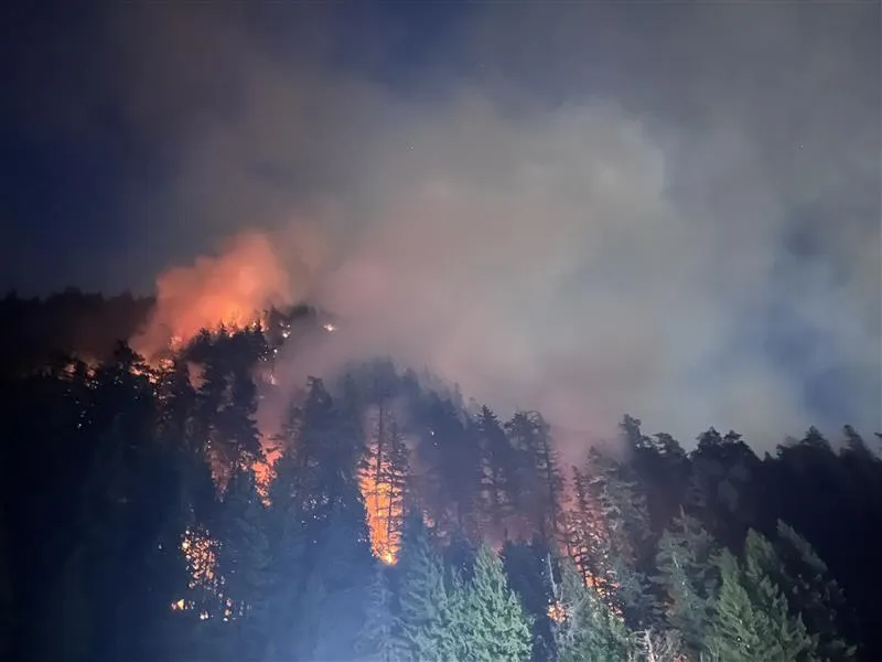
The air around Kelowna International Airport on July 6, 2025, carried a heavy, smoky smell, a severe reminder of the land’s struggle. It was late afternoon when thin smoke plumes turned into a big cloud behind the busy airport. For people living in Ellison, a quiet community in British Columbia’s Okanagan Valley, this was not just a faraway event. It was a sudden, scary threat. The Whelan Creek wildfire began its swift climb up the hillside, painting the calm summer sky with an uneasy orange glow. Memories of the catastrophic Kelowna fires in 2023, which brought so much fear and destruction, weighed heavily on everyone’s minds. Could this fire turn into another nightmare?
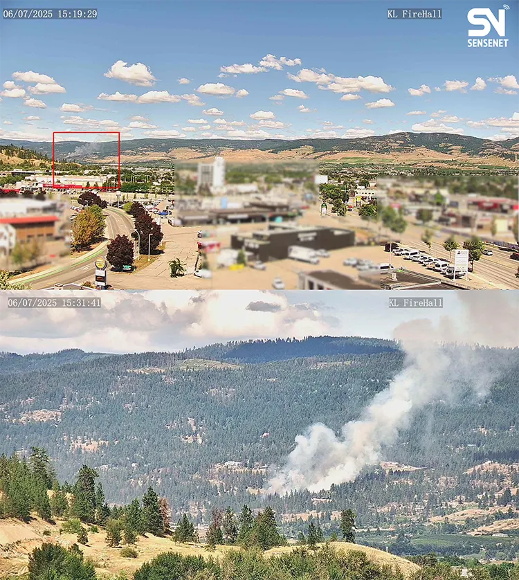
The fire started at 3:16 p.m. Crucially, Sensenet’s smart cameras and ground sensors were like watchful guardians. They saw the very first signs of the fire by 3:19 p.m., just three minutes after it began, as shown in Figure 1 Sensenet Camera Snapshots. This quick detection led to an immediate alarm for the local fire department. Our real-time tracking helped create an early warning and vital situational awareness right from the start. But why did this fire grow so fast and get out of control in just a few minutes? And if the quick response and firefighting efforts hadn’t been so successful, could the 2023 disaster have happened again?
The fire is thought to have started because of human activity. Initial reports came in just before 4 p.m. on that Sunday. Its first impact was big and immediate. Soon after, the fire, covering about two hectares, led to stopping all flights at Kelowna International Airport. Air tankers and helicopters from BC Wildfire Service quickly joined the fight from above. On the ground, police moved fast, helping people living on Rockface Road, Upper Booth Road, and Dead Pine Road to leave their homes as a safety step.
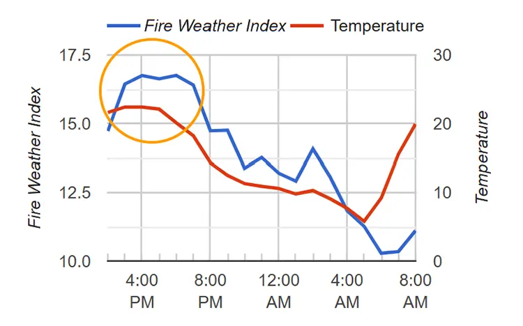
So, why did this fire grow so quickly? When we looked at the environmental conditions that fed its rapid spread, weather station data showed that on July 6, 2025, between 3 and 4 p.m., both the Fire Weather Index (FWI) and the air temperature reached their highest points. This created perfect conditions for a fire to start and spread fast, as clearly shown in Figure 2 FWI and temperature plot. These high numbers meant the landscape was very ready for a fast-moving fire, and the continued high FWI indicated a constant risk of rapid growth in the hours that followed.
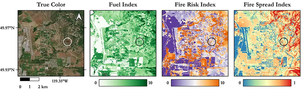
If the response was not fast and successful, what could have happened? Looking deeper, our analysis, including Sensenet’s Fire Risk Index map and Fuel Index map, seen in Figure 3, showed precisely why this spot was so dangerous. The fire began in an area with a lot of dry fuel, making it easy for flames to catch and spread. Our Fire Risk Index map was also very high at the ignition point, confirming this danger. More concerning, our Fire Spread Index map clearly highlighted the serious threat of the blaze rapidly climbing uphill into the thick forest nearby. This kind of terrain can quickly turn a ground fire into a much more dangerous crown fire, where flames jump from treetop to treetop, something we sadly saw happen recently in Squamish. The Sentinel-2 true color image, also in Figure 3, vividly displays the burnt area on July 7, showing the immediate impact. This combination of dry plants, ready fuel, and dangerous spread potential meant this fire could have become a huge disaster very quickly.
Sensenet’s satellite technology played a key role in understanding what might happen next. Through detailed fire spread analysis, as seen in Figure 4, we used data on fuel type, vegetation cover and density, biomass, dryness and moisture levels, and wind patterns, along with real-time weather information, to predict how the fire would likely spread and grow in the next 24 hours. This kind of prediction helped emergency teams know where the fire might go and move their resources to the best spots to fight it. This was a crucial difference from the devastating, unpredictable fires that caused so much damage in Kelowna in 2023.

As the days passed, the tireless work of fire crews from Ellison, Kelowna, and Joe Rich, with strong support from BC Wildfire Service aircraft, brought the fire under control. By July 7, the situation improved greatly. At 4:53 p.m. on that Monday, good news arrived for the few homes that had to leave. The evacuation order for places like 5250 Dead Pine Drive and several spots on Rockface Road was lifted, letting people go back home by 6 p.m. This move away from immediate danger truly showed the incredible effort and tireless dedication of every firefighter and responder on the ground and in the air. Their brave and strategic work was remarkable, and the clearer understanding of the situation, humbly supported by Sensenet’s insights, played a part in helping them contain the fire so well.
While the immediate danger has eased, being careful is still important. An evacuation alert is still in place for these homes and for 106 other properties nearby. This alert reminds people to be ready to leave quickly if things change. Thankfully, no buildings were lost, which brought a lot of relief to those whose lives were turned upside down. The Beasley Community Centre was set up by the Regional District of Okanagan-Similkameen as a safe place for those who had to leave their homes. The Whelan Creek wildfire is now officially under control, showing how well different groups worked together to fight it.
The Whelan Creek wildfire, now contained at 4.9 hectares, leaves behind a landscape marked by both challenge and strength. Although the immediate threat has passed, this event strongly reminds us of nature’s power and the strength that comes from working together. The community of Ellison, having faced the fear of uncertainty, now looks forward to rebuilding, held together by what they’ve been through and a deeper appreciation for their beloved home. The quick suppression of this fire, greatly aided by Sensenet’s early detection and continuous situational awareness, was crucial in preventing a disaster like the one seen in 2023.