
The Red Earth East Inferno: A Satellite's Perspective on Alberta's Boreal Battle
July 7, 2025
Dr. Mohammadali Hemati, Remote Sensing Specialist.
Have you ever looked at a map and wondered what hidden forces shape the landscape beneath?
In late May 2025, our satellite systems watched as a familiar and formidable force awakened in Alberta’s boreal forest: the Red Earth East Complex wildfire. This wasn’t just another blaze;
it was a testament to nature’s power, fueled by precise conditions and tracked by the unblinking eyes of our orbital sentinels.
The area east of Red Earth Creek, a vital ecological zone, became the focal point of a massive challenge, demanding every tool at our disposal.
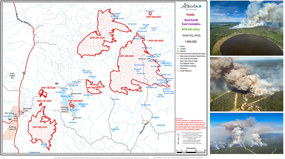
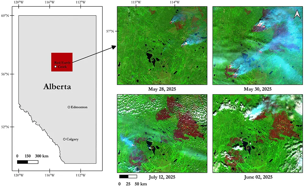
To understand the immense scale of this event and its location within the province, Figure 1 provides a comprehensive overview, showcasing an official map of the fire’s progression from the Government of Alberta, alongside compelling images captured by Alberta Wildfire, offering a visceral look at the inferno.
The spark that ignited this sprawling inferno was a lightning strike, a common occurrence in the vast wilderness. But why did this particular strike lead to such an unprecedented event? The secret lay in the land itself.
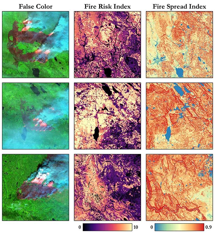
Our Sensenet Fire Risk Index (Figure 2), a sophisticated product that combines satellite data on vegetation type, biomass, dryness, land condition, temperature, humidity, and precipitation, revealed a landscape ready to explode.
This index showed alarmingly high risk levels in the very spot where the lightning hit. The forest here, a mix of dense coniferous trees like spruce and jackpine, alongside aspen and critical peat bogs, had been baking under prolonged hot and dry conditions.
This drought had turned the forest into a colossal tinderbox, its fuels bone-dry and eager to burn. Figure 2 also includes our Fire Spread Index, which accounted for topography, fuel types, and wind, indicating the immense potential for rapid fire propagation across the region even before the first flame appeared.
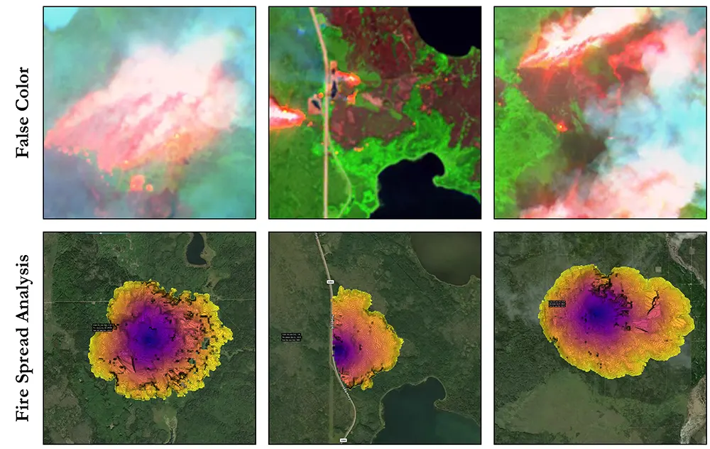
Once ignited, the fire’s growth was nothing short of explosive. Within days, the Red Earth East Complex, dominated by fires like SWF092 and SWF100, surged across thousands of hectares. How do we track such rapid, relentless progression from afar? Our Sensenet Fire Spread Analysis (Figure 3) was key.
This powerful tool allowed us to predict how the fire would grow from its very beginning, combining real-time weather data, fuel conditions, and detailed topographic information.
Figure 3 shows our predicted fire growth compared to the actual burnt area captured by later satellite images.
This ability to forecast the fire’s path was critical for deploying firefighters and equipment where they were needed most, often ahead of the flames.
The sheer speed of this fire was driven by a deadly combination of high temperatures, extremely low humidity, and powerful, shifting winds that fanned the flames and carried embers far ahead, creating new spot fires. The dense coniferous stands often resulted in crown fires, where the blaze leaps through the treetops at astonishing speeds.
Meanwhile, deep within the ground, the fires smoldered in peat bogs, burning slowly but persistently, a hidden challenge that is critical for a proper response.
The impact of this relentless fire was immediate and severe for both nature and people.
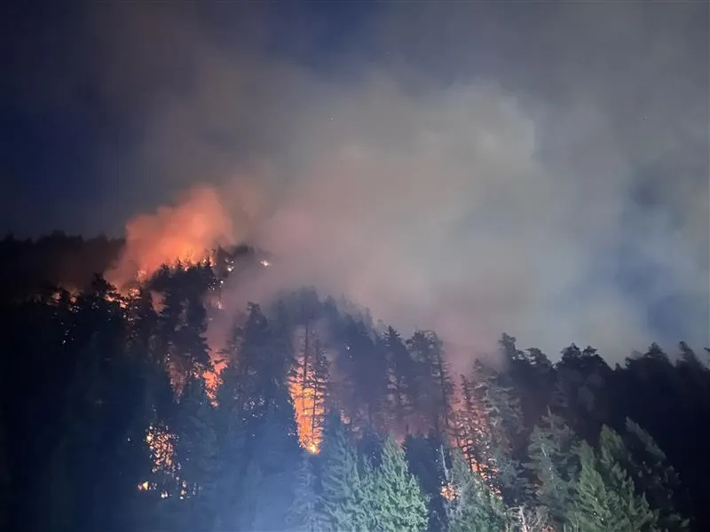
Imagine having to leave your home with only moments’ notice, abandoning everything you know. Thousands were swept into the evacuation, affecting crucial communities like Red Earth Creek, Peerless Lake, Trout Lake, and Loon Lake, all situated in the path of this monstrous blaze within the province of Alberta, as clearly depicted in Figure 4, which outlines the fire’s grim location.
As the Kee Tas Kee Now Tribal Council bravely coordinated efforts, families from communities like Peerless Lake and Trout Lake were ordered to evacuate, urged to bring essential belongings and prepare for an uncertain return.
Many sought refuge in evacuation centers, including those established in larger cities like Edmonton, where the focus quickly shifted beyond basic needs to supporting the emotional, mental, and social well-being of the displaced.
Essential services were paralyzed; schools closed, court sittings were suspended, and daily life ground to a halt. The sheer scale of destruction was heartbreaking, particularly in communities such as Chipewyan Lake, where nearly half the buildings, including the vital health center and water treatment plant, were tragically consumed by the flames.
Fighting such a massive and aggressive fire requires an immense coordinated effort.
Firefighters on the ground, supported by helicopters dropping water and airtankers releasing fire retardant, battled tirelessly.
Heavy equipment worked to carve out fireguards, creating breaks in the fuel that the fire couldn’t cross.
Strategic aerial ignitions, like those carried out for SWF092, were used to burn off fuel in a controlled manner, preventing the main fire from reaching those areas. But the challenges were immense. Thick smoke often blinded aerial operations, making it impossible for pilots to see and sometimes even causing firefighters to lose radio contact.
The soft, wet terrain of the muskeg also made it incredibly difficult for heavy machinery to operate effectively.
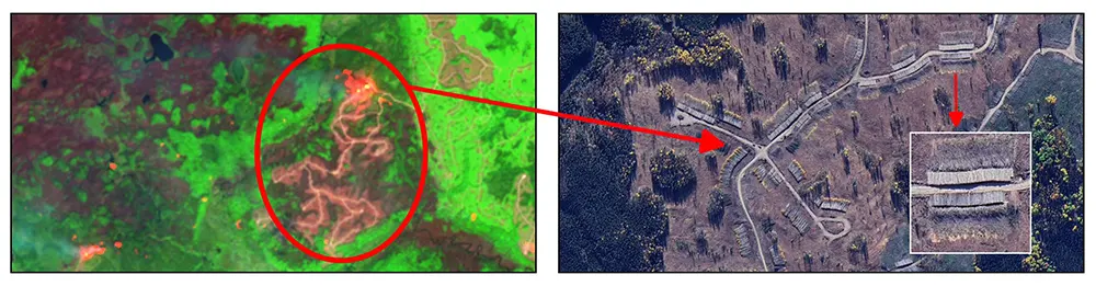
In the midst of this raging inferno, our satellite imagery, particularly the zoomed-in view of Figure 5, highlighted a critical vulnerability: a large wood-cutting, lumber, and log business directly in the fire’s path. This area, laden with neatly stacked piles of freshly cut timber, processed lumber, and logging debris, represented an enormous, ready fuel source. When the fire front swept through, these concentrated fuel piles ignited with terrifying intensity, creating localized super-hot zones that were incredibly difficult to extinguish. Even after the main fire had passed, satellite thermal anomalies indicated that these dense piles of wood could smolder for weeks, deep within their cores, acting as persistent hot spots that threatened to re-ignite surrounding areas with a shift in wind or an increase in temperature. The impact on such businesses is catastrophic; beyond the direct destruction of valuable inventory and infrastructure like sawmills and storage facilities, the long-term disruption to operations, loss of timber supply, and the immense cost of recovery can cripple entire segments of the regional economy, transforming a thriving enterprise into charred ruins.
The true value in the face of such a crisis lies in the speed of response, a testament to the seamless integration of technology.
Every hour saved, every accurately predicted shift in the fire’s path, means homes saved, lives protected, and critical ecosystems shielded from total devastation.
Our ability to process vast streams of data from high-orbiting satellites, combined with vital measurements from in-situ ground sensors create a powerful, real-time intelligence network.
This synergy can empower incident commanders to react not just within days or hours, but within minutes, anticipating the fire’s next move. It’s a relentless, high-stakes chess match against a force of nature, where our combined sensors become the eyes, the mind, and the early warning system. As the Red Earth East Complex slowly yields to the tireless efforts, the indelible scars it leaves are a grim reminder.
Yet, they also stand as a powerful testament to humanity’s unwavering will to defend, adapt, and innovate, pushing the boundaries of technology to stand guard over our world.